Berwickshire is a famously unspoilt landscape packed with historically interesting places, many of them with connections to Wedderburn. Within 21 miles of the castle you will find all of the suggested attractions and activities listed here:
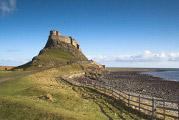
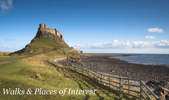
Holy Island (Lindisfarne)
Given to St Aidan in AD635 by the King of Northumbria, Holy Island was one of the principle centres of Christianity during the Dark Ages. The castle you see today (for example while speeding by on the train from London to Edinburgh) is a Tudor castle later remodeled by Sir Edwin Lutyens to form a dramatic private house, now open to the public. Predictably the location for about a million film shoots (from James Bond to the Scarlet Pimpernel), while on the island take a look at the pub, the remains of the medieval Priory and the endless sandy beaches. USE THE TIDE TABLE BEFORE CROSSING THE CAUSEWAY. NU 138 418
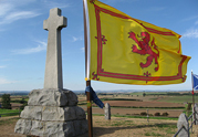
Flodden Field.
If heading South over the border into North Northumberland it is worth walking up Flodden Field, the site of the greatest battle ever fought in this region, as well as one where both Sir George Home of Wedderburn and his eldest son died. On 9th September 1513 it is estimated that 30,000 men died here, a crushing English victory. The memorial was erected in the 19th century. NT 890 373
The Chain Bridge Honey Farm.
A fascinating business with a family-friendly visitor centre. The farm keeps 1800 bee hives, some of which you may see during the winter by the North Gate at Wedderburn. Find out how the renowned honey and beeswax cosmetics are prepared for sale and see the unexpected display of vintage Caterpillar tractors and other memorabilia. Open weekdays November to March, 7 days April to October only. Admission free. NT 935 507
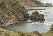
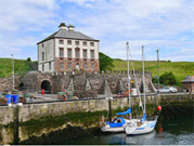
Cove Harbour and Pease Bay.
A visit to Cove is as close as you are likely to come to the sensation of stepping back in time. Park at the top of the cliff in Cove village and pop out at sea level via a tunnel carved through the solid rock. The harbour is still used by small boats collecting lobster pots (creels). Cove Harbour is cared for by the Cove Harbour Development Trust. Please treat it as conservation area. The cliff-top path heading South East leads to Pease Bay, under 1km away. NT 784 717
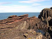
Siccar Point.
Siccar Point is the unlikely birthplace of modern geology. Professional and amateur geologists will travel around the world to see this place, known to them as ‘Hutton’s Unconformity’. Even if the scientific history doesn’t excite you, the beach walk and wild landscape is well worth a visit. To get there, at low tide (always check the tide table) walk East from Pease Bay along the shore for about 1km. NT 812 710
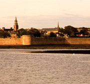
Berwick-Upon-Tweed.
The only entirely walled town in Britain, Berwick's walls were designed by the same man responsible for those surrounding Lucca in Italy and built for Queen Elizabeth I. Also notable for its three famous bridges across the mouth of the Tweed. Berwick is the home of the Berwick Cockle, and the scene of several well known paintings by L.S.Lowry. There is a marked 'Lowry Trail' that you can follow around the town. It is possible to walk around the top of the walls. The barracks by the Cowgate are of partiicular interest- formerly the home of the King's Own Scottish Borderers (KOSBs) and designed by the great Sir John Vanbrugh, architect of Blenheim Palace and Castle Howard.
Eyemouth.
Eyemouth has been a fishing port since the 13th century and remains one of the busiest in Scotland, with around 80 boats. You can experience the atmosphere of a busy working fishing port right up close at the harbor wall, where the variety of small boats is a sight to behold. Get up early enough and you can also witness the fishmarket! There is also a small sandy beach with rock pools. Try Giacopazzi's ice cream, alongside a variety of good local shops.
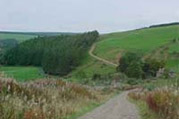
Walk the Southern Upland Way.
This is the longest of Scotland's walks at 212 miles and traverses the whole border country from Portpatrick in the West to Cockburnspath in the East. Passing just north of Duns the Longformacus - Abbey St.Bathans section is very close by and particularly beautiful. NT 693 572
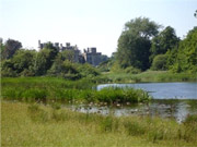
Walk at Duns Castle.
Only two miles from Wedderburn on the West side of Duns, a significant part of the Duns Castle estate is open to the public. Walk up Castle Street and through the gate, which is signposted. The surprisingly named Hen Poo is in fact a very pleasant landscaped lake and the estate provides extensive paved and un-paved walks. If you go up the steps on the right after passing the gate you will find your way to the top of Duns Law, to site of the medieval town of Duns and an excellent viewpoint. Open all year, admission free. NT 782 542
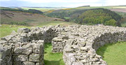
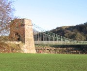
Walk to Edin's Hall Broch.
An Iron Age hill fort (2000 years old), it is hard to decide whether to include Edin's Hall (NT 772 602) under activities or historic buildings, but one thing is for sure- you will enjoy a bracing walk across the foot hills of the Lammermuirs to see it, and it is well worth the effort. A very entertaining suspension foot bridge crosses the rapids of the Whiteadder river (known as the 'Strait Leap' NT 786 604) where ancient tin mine (maybe) tunnels can be seen in the cliff face.
Ford and Etal Estate.
The sprawling Estate of Lord Joicey includes an idyllic thatched English village and all that this entails, including the Heatherslaw water mill and bakery (NT 934 383) and a miniature railway, the Ford plant nursery and Lady Waterford Hall NT 925 395. Further South, near Wooler, is the Fenton Centre, a working farm, nature trail, café and shop. www.ford-and-etal.co.uk
Please note
For all expeditions by road or on foot we recommend that you use Ordnance Survey maps that are available to purchase online. Each location here is shown with a grid reference. Post codes are sometimes not useful in very rural areas! Type the number (for example NT 808 528) into the search box at:
Ordnance Survey Get-a-map
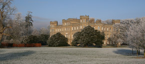
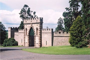
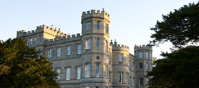
Wedderburn Castle, Duns, Berwickshire, TD11 3LT, Scotland, UK.